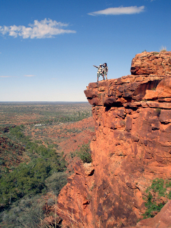
See one of the world's oldest mountain ranges using the oldest for of transport: your feet. As it traverses the Macdonnells, the Larapinta tail dips in and out of waterholes and gorges, offering views of the red center desert from on top of the range.
Distance: 223KM
Location: West Macdonnell Ranges, Northern Territory, Australia
Ideal Time Commitment: 12-16 days
Best Time of Year: April to September
- Watching for euros bounding across the eponymous Euro Ridge, with Alice Springs still in sight.
- Swimming off the day's sweat at the waterholes such as Ellery Creek Big hole and Redbank Gorge.
- Hiking through predawn chill to Counts Point for a sunrise view over the Red Center.
- Balancing along the knife-sharp Razorback ridge near Hugh Gorge.
- Looking east over much of the trail's journey as you stand atop Mt Sonder at the trail's end.
The Trail's 223km of twists, turns, spinifex, mountains and gorges are divided into 12 sections, each somewhere between 13km and 31km in length. Every section represents a day of walking, and each is determinedly intent on showing off hidden mountain wonders.
When it's been a long haul across the desert plain, switching from on line of mountains to the other, you've finally arrived at Hugh Gorge. Inside the gorge, the rock walls are as smooth as plates, towering above you as you step around waterholes.
When the sun hits the morning, the mercury rises almost instantly by 20 degrees. It's a long hot day across the ridge, the exposed rock feeling like the very bones of the land, but you're weaving through dry Spencer Gorge to Birthday Waterhole. The end is near.


No comments:
Post a Comment