Friday 19 April 2013

Raft the Source of Nile


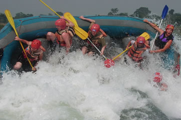
The Nile: It's exotic, historic and, yes, somewhat daunting. But forget about those Egyptian cruise ships lazing their way along the river - if you're looking for a real Nile adventure, head to its source in Southwestern Uganda and get in a raft.


Location: Southwestern Uganda
Ideal Time Commitment: One To Two Days
Best Time of Year: Year Round

  • Feeling the rush of some of the best class V white-water rafting on the planet.
  • Glimpsing the untouched jungle and wild surroundings of the river.
  • Witnessing mountain gorillas in their natural habitat in the far southwest of Uganda.
  • Revelling in the wonder that you are standing at the source of the Nile- the longest river on the planet.
  • Speeding through the jungle on a mountain bike- just another activity to experience in the adrenalin capital of Africa.
  • Looking for crocodiles in the Nile- hopefully not when you are swimming in it!
The Nile stretches an astonishing 6680km, rising in the fertile greenery of Uganda, winding through the parched desert of Sudan and finally entering the historic sands of Egypt. Along the way, it transforms from a raging, rapid-choked thrill ride to a lazy, wide expanse navigated by riverboats overflowing with tourists.
The rapids there are graded class V- and since there's only one class above that, VI, you get the picture that this won't be a placid float down the river. You can expect big standing waves, rocks, drops, foaming hydraulics and plenty of white water. It's nothing that the raft, your guide, and hopefully you, can't handle.

Climb Mt Roraima, Venezuela


Here be dragons- at least, that's how it feels. For to ascend Venezuela's mightiest tabletop mountain, via a tangle of forest, an army of sandflies and punishingly slippery slopes, is to enter a prehistoric, and utterly unique, lost world.

Elevation: 2810 m
Location: Canaima National Park, Southeastern Venezuela 
Ideal Time Commitment: Five to Six Days
Best Time of Year: November to April
  • Watching waterfalls tumble off the top of neighboring tepui Kukenan- which, in Pemon, means "Place of Death".
  • Spending the night in Roraima "hotel", sandy areas sheltered by rock overhangs.
  • Scouring the tepui top for curious indigenous species- tiny black toads and unusual blooms.
  • Taking a dip in the jacuzzis- ice clear, icicle-cold pools on Roraima's summit.
  • Waiting for the mist to clear, to give sweeping, international views of where Venezuela, Guyana and Brazil meet.
  • Nursing wobbly legs, a sunburned nose and myriad jejane (sandfly) bites with a cold beer back in Paraitepui, after a climb well done.
"Inaccessible, accept by means of balloon." That was the verdict on Mt Roraima in 1872. By the latter half of the 19th century, several Western explorers had set their eyes on the highest of Venezuela's strange table-top shaped mountains, and all had determined it quite insurmountable- its foliage too dense, its situation too remote, its upper flanks too extraordinarily sheer.
Often the mesa is draped in a dramatic tablecloth wispy white (it rains virtually every day). But when the linen is whipped off, the vastness is revealed; from here, you can look out over three countries, and across to other tepuis, which all have their own secret summits.


Pedal The Camino De Santiago


For centuries, pilgrims have been foot-slogging their way across Northern Spain to Santiago De Compostela, to pay homage to the remains of the Apostle James. Today, a new breed comes on wheels and 27 gears.

Distance: 783 km
Location: Northern Spain
Ideal Time Commitment: Two Weeks
Best Time of Year: May to June, September to October

  • Setting your wheels down, ready to ride, on the French border at Puerto de lbaneta, the same Pyrenean pass Napolean used to launch his 1802 occupation of Spain.
  • Drinking wine from a water fountain through La Rioja.
  • Carrying a stone to place at Cruz de Ferro, the cross atop the Montes de Leon.
  • Getting your Credencial del Peregrino stamped each day as you cycle west.
  • Threading through weary walkers as you arrive in Praza do Obradoiro, beside Santiago's cathedral.
Beginning in the border town of Roncesvalles, the ride descends the Pyrenees into the city of Pamplona before crossing the wine region of La Riojam where fountains dispense wine for pilgrims. Crossing the high plateau between Burgos and Leon is the Camino's version of penance- a long, bland haul that has many walkers jumping on buses. Here, you'll be very glad you came by bike.
Across the epic O Cebreiro climb, the Camino finally enters Galicia, a world apart from the dry plateau. Rainswept and green, this region provokes a hilly final 150km into the mazelike old town of Santiago, where one final scallop shell- the symbol of St James- marks the pilgrimage's end outside the city's cathedral.

Sunday 14 April 2013

Kayak Mosquito Bay


Nature can be fantastically weird. And perhaps nowhere more so than in Puerto Rico. For here, in a few select bays- of which there are just a handful worldwide- you can kayak right through the world's most wonderful watery light show.

Distance: 6KM to 10 KM
Location: Mosquito Bay, Vierques, Puerto Rico
Ideal Time Commitment: Two to Four Hours
Best Time of Year: Around the new moon, year-round
  
  • Watching the sun set over the lapping Caribbean with a cool rum cocktail and a blast of salsa romantica.
  • Navigating around the mazelike mangrove trees, which become an otherworldy- and slightly creepy- realm in the darkness.
  • Tracing myriad fish gliding through the bioluminescence, leaving trails of glowing blue in their wakes.
  • Gazing up at a blanket of stars- and then down, to see those same celestial speckles of perfectly reflected in the waters below; watch out for shooting stars.
  • Dipping you paddle into the bay of delight at the halo of light created around its gentle thrust.

Pyrodinium bahamense  are ancient species of dinoflagellate- or minuscule spheres of sea gunk, to you and me. These 446-billion-year-old organisms very much like the water of Puerto Rico, at least in a few choice spots. They like the vitamins released by the roots of red mangrove trees, the relatice lack of any pollution and the limited tidal exchange of their favoured bays. And because they like it here, they treat us to their unique pyro-tastic show.
There are fewer than 10 places worldwide where this phenomenon occurs, and Puerto Rico is arguably the most spectacular.  There are three bioluminescent bays on the archipelago.
Here, you can head out after sundown in a kayak and watch as the world beneath you starts to glow. This is not a physical test of an adventure, but a chance to see nature at its most beautifully bizarre.


Trek Corsica's GR20 Trail


Lace up your hiking boots to pierce the unforgiving granite heart of Corsica. Tramp rugged trails across shepherds' pastures, past high alpine lakes and through pine-scented forests on the route lauded as Europe's toughest trek and France's grandest Rondonnee.

Distance: 170KM
Location: Corsica, France
Ideal Time Commitment: 12 to 16 Days
Best Time of Year: June to Mid-July, Mid-September to Mid-October

  •  Catching your breath at the summit of 2706m-high Monte Cinto- then gasping at the breathtaking panoramic vistas across northern Corsica.
  • Drinking in the sunset at the Refuge d'Ortu di u Piobbu after your first day's hike, before tuckering into hearty soupe corse.
  • Tackling the chains and ladders leading across the vertigo-inducing Cirque de la Solitude.
  • Admiring the exquisite glacial lakes of Capitellu  and Melu from the path descending from high-level pass Breche de Capitellu- the trail's highest point.
  • Watching climbers- and perhaps a mouflon- haul themselves up the crags of the Aiguilles de Bavella.

Corsica's iconic Grande Randonnee (meaning, literally, "Great Walk") was pioneered 40 years ago, the brainchild pf alpinist Michel Fabrikant. As the Coriscan name Fri li Monti suggests, the rail leads hikers across- and in many cases over- the mountainous interior of this rugged Mediterranean island, stretching 170km between the northern village of Calenzana and Conca, the southern trailhead.
As it's often seen as Europe's toughest long-distance trek, completing all 16 stages of the GR20 is considered a badge of honour for hardcore hikers. But it's also a chance to penetrate deep into the island's remote uplands, accessing the natural and cultural treasures that seem most inaccessible.
The payoff though, is immense. The Park Naturel Regional de Corse, created in 1972 to coincide with the opening of the GR20 trail that weaves through its higher reaches, protects areas of stupendous beauty- alpine lakes, forests of chestnut and oak, stands of Laricio pine and unique Coriscan scrub called the maquis- among which lammergeier and osprey soar above wild boar, Coriscan mouflan and, of course, intrepid trekkers.

Sunday 7 April 2013

Explore Kruger's Wilderness Trails

 Getting deep into Africa doesn't mean spotting the big five from the comfort of a Safari Jeep. It's getting out, on foot, into quiet wilderness isolation, seeing the details that make the whole, and feeling the heart of Africa beating strong.

Distance: Up to 50KM
Location: Kruger National Park, South Africa
Ideal Time Commitment: Seven Days
Best Time of Year: Year Round
Essential Tip: Obey your guide unquestionably- your safety depends on it

  • Immersing yourself in African nature: no barriers or fences, just you and the bush
  • Revelling in a silence so profound, you can hear your own heart beat
  • Thrilling at the real, though carefully managed, danger of meeting animals face-to-face in the wild
  • Spotting a rarely seen bird like the gorgeous, elusive Narina trogon- and finding that just as exciting as sighting one of the Big Five game
  • Seeing the ancient, mystical rock art of this area's earliest inhabitants
  • Falling asleep to the night-time sounds of the bush
The Kruger's National Park is a vast swathe of bushland on South Africa's eastern border with Mozambique. Covering nearly 20,000 sq km, it's on of the largest national parks in Africa, a natural world little altered since the indigenous San people first lived here 20,000 years ago. Game spotters have been coming here since 1898, when the park was founded, but most visitors still see the park from behind the windscreens of their vehicles- only disembarking in the safety of rest camps.
With all those caveats, walking in the wilderness of the Kruger National Park is nothing short of an adventure of a lifetime. This is a magnificent journey on which you can feel like the first human that trod the Earth. You'll travel through a glorious African Garden of Eden, and shed the burdens of modern life. These days in the wilds could change you forever.


Sail Croatia's Dalmatian Coast


Weigh anchor, hoist the mainsail, and with the islands of Dalmatia before you, sail between the historic and natural jewels of Croatia's Adriatic coastline. When a little landlubbing appeals, come ashore to forested coves, fishing villages and ancient fortified towns.

Distance: 360 KM
Location: Dalmatia, Croatia
Ideal Time Commitment: Two to Three Weeks
Best Time of Year: May to Mid-July, Mid-August to September

  • Arriving in a deserted cove, dropping anchor into the azure depths, and plunging in.
  • Wandering in awe through ancient World Heritage- listed towns and peaceful, historic fishing villages.
  • Smelling the scent of sun-warmed pine wafting over your boat as you pass forested islands.
  • Catching fish as you sail and barbequing them over the coals on a remote beach.
  • Feeling the salt spray fresh on your face as the maestral breeze fills your sails and you cruise to the next gorgeous anchorage.
  • Savouring fabulous seafood alfresco at the tiniest harbourside restaurant, and sipping Croatian wine as you laugh with the locals.
 The Dalmation coast of Croatia is 360 km long, stretching from the town of Zadar in the north to the Bay of Kotor on the border with Mentenegro to the south. It takes in the dramatic and historic cities of Split and Dubrovnic, over a thousand islands, countless beaches, jewel-like coves and quiet bays.
Island hopping off Dalmatia is as much about the stopping as the time at sea. Cruise your yacht among the 147 (mostly uninhabited) Kornati Islands, where impossibly clear waters fringe sculpted cliffs and caves. Or try Mljet Island, which supports the eponymous densely pine-forested national park. Then check out the magnificent Diolcletian's Palace in Split, started in AD 295, and the Unesco World Heritage city of Dubrovnik, founded in the 7th Century.
The heartbreakingly gorgeous island of Hvar, with its olive groves, lemon trees and perfect medieval villages, has been well and truly "discovered", so if you want to see perhaps the most beautiful island in Dalmatia, you'll have to put up with the crowds. There are countless other nameless stretches of sand and secret coves that only a sailor can get to.


Monday 1 April 2013

Hike California's John Muir Trail


Step out into a wilderness that inspired over a century of conservation, following a historic trail through the lofty ranges, peaceful meadows, bear-grazed forests and fresh-air splendor of California's Sierra Nevada.

Distance: 344KM
Location: Sierra Nevada, California, USA 
Ideal Time Commitment: Three Weeks
Best Time of Year: Mid-July to Early September
  •  Watching the sun set and rise over Thousand Island Lake.
  • Marvelling at the basalt columns of the Devil's Postpile- and nipping to nearby Red Meadows Resort for a hot-spring-powered shower.
  • Looking out for lupins, Indian paintbrush and other wildflowers, as well as mule deer, marmots and black bears.
  • Camping beside mountain-hugged Evolution Lake, one of the JMT's remoter reaches.
  • Casting a line (if you have a fishing permit) into the five serene pools of Rae Lakes.
  • Standing atop Mt Whitney, gazing over the rugged wilderness you've just traversed.
This trail across Muir's beloved Sierra Nevadas, from the great granite valley of Yosemite to Mt Whitney, bears his name. There's lots of up and down (walk the entire route, north to south, and the total ascent is 12,800m; walk south-north and it's 14,234m). But, despite this, the trail seldom feels tough- gradients are mostly gentle, the way largely sheltered. The toughest part is being self-sufficient. There are no real towns or shops en route, and hikers must carry much of what they need, meaning weeks of dried food and watery porridge.
But the trail compensates for this culinary fatigue with sheer wow. This is magnificent countryside, where every step seems to reward with yet another deer-nibbled valley of lake-reflected mountain range; where every night's camp, even if busy with other hikers, makes you feel a bit like a pioneer.
Your legs ache, your armpits smell, and your shoulders burn from the weight of your backpack, but you've never felt more alive.


Take On the Tour Du Mont Blanc


Do a complete circuit around the European Alps' highest mountain, wandering through three countries as you go, and crossing a succession of passes in sight of some of the finest rock spires and peaks on the continent.

Distance: 167 KM
Location: France, Switzerland and Italy
Ideal Time Commitment: 10 to 14 days
Best Time of Year: Mid-June to Mid-September 

  • Spending a night at Rifugio Elisbetta, almost in touch of the ice falls of the Glacier de la Lee Blanche.
  • Border hopping as you cross Col de la Seigne and Grand Col Ferreyt.
  • Peering down onto the heavy crevassed Glacier du Tirent from the 2665m Fenetre d'Arpette.
  • Marvelling at the ever-changing view of Mont Blanc along the trail's final stretch, the aptly named Grand Balcon Sud on the slopes of the Aiguilles Rouges.
  • Reflecting on the mountains-literally-as you gaze across the surface of Lac Blanc.

The Chamonix Valley is arguably the European Alps' most appealing and fashionable destination. This international route has sections in France, Italy and Switzerland, and the views encapsulate the entire Alpine landscape, taking in the valleys, passes and mountains that crowd its rim.
The TMB is a challenging route. Even the easiest variations mean you'll be ascending and descending more than 8000m. If you take the most strenuous route, it becomes as much as 11,000m of climbing. That means you'll be ascending and descending at least the equivalent of Mt Everest from sea level as you circuit this European Mountain icon.
The climb at Col de la Seigne is long and steady- more than 600m of ascent since lunch. Wind whips up from the valley but you've not only reached a pass, you've reached another country.
If the views seem good now, it's just a foretaste of things to come. Two days from now, at the head of yet another 600m climb, you'll step out from the front door of Rifugio Bertone into a broth of dawn and cloud.

Tuesday 19 March 2013

Rock Climb at Railay, Thailand


Scale limestone cliffs high above some of Asia's finest and most scenic beaches, staring out over the Andaman Sea as you cling to walls of rock high above sun-seeking beachgores.

Distance:5M-125M
Location: Railay, Phra Nang Peninsula, Krabi, Thailand
Ideal Time Commitment: Three days to three weeks
Best Time of Year: November to February

  • Lounging about in Ton Sai, where climbers drop in to drop out from the world.
  • Hanging out- literally- on Thaiwand Wall, with Thailand's Andaman coast stretched out below.
  • Walking to Sa Phra Nang, a hidden lagoon inside the cliffs between Rai Leh East and Phra Nang.
  • Sipping an evening beer on the sand in front of a beach bar in Ton Sai as the sun sets over the Andaman Sea.
  • Deep-water soloing on a cliff overhanging the ocean.
 Thailand is framed with great beaches, but it's not often you can enjoy a bit of postcard-perfect paradise while grunting your way, finger hold by finger hold, to the top of a rock wall. Welcome to Railay, a jagged peninsula of lush limestone cliffs west of the city of Krabi.
On the wall of One Two Three, at the southern end of Hat Rai Leh East, you're spreadeagled against the cliff, looking like a star jump half completed. Your fingers are jammed into tiny holes and your eyes flicker about in search of the next ledge for your foot. Ropes hang like from bolts like spaghetti, and local climbing guides scurry barefoot up the cliff's jagged edges, making it look simple. In comparison, you feel about as smooth as the choppy ocean below.
Next morning you wonder along Hai Rai Leh West, the most perfect strip of sand on the peninsula. Today the 200m-high tower of rock that looms above its southern end- Thaiwand Wall- is your climbing goal.


Walk Australia's Larapinta Trail

See one of the world's oldest mountain ranges using the oldest for of transport: your feet. As it traverses the Macdonnells, the Larapinta tail dips in and out of waterholes and gorges, offering views of the red center desert from on top of the range.

Distance: 223KM
Location: West Macdonnell Ranges, Northern  Territory, Australia
Ideal Time Commitment: 12-16 days
Best Time of Year: April to September

  • Watching for euros bounding across the eponymous Euro Ridge, with Alice Springs still in sight.
  • Swimming off the day's sweat at the waterholes such as Ellery Creek Big hole and Redbank Gorge.
  • Hiking through predawn chill to Counts Point for a sunrise view over the Red Center.
  • Balancing along the knife-sharp Razorback ridge near Hugh Gorge.
  • Looking east over much of the trail's journey as you stand atop Mt Sonder at the trail's end.
Such as it's beauty, accessibility and infrastructure, the Larapinta has quickly become one of the most popular long-distance tails in the country.
The Trail's 223km of twists, turns, spinifex, mountains and gorges are divided into 12 sections, each somewhere between 13km and 31km in length. Every section represents a day of walking, and each is determinedly intent on showing off hidden mountain wonders.
When it's been a long haul across the desert plain, switching from on line of mountains to the other, you've finally arrived at Hugh Gorge. Inside the gorge, the rock walls are as smooth as plates, towering above you as you step around waterholes.
When the sun hits the morning, the mercury rises almost instantly by 20 degrees. It's a long hot day across the ridge, the exposed rock feeling like the very bones of the land, but you're weaving through dry Spencer Gorge to Birthday Waterhole. The end is near.

Cycle the Annapurna Circuit


The famed Annapurna circuit might be dying a death as one of the world's great hiking trails, but it's emerging as one of the great aspirational mountain bike tours. Would you dare the brave the 5416M pass on two wheels?

Distance: 300 KM
Location: Annapurna Region, Nepal
Ideal Time Commitment: 2 weeks
Best Time of Year: March to April, October to November

  • Challenging yourself to cycle across a high suspension bridge over the Marsyangdi River.
  • Sharing the thrill and the view of Thorun La with your bike.
  • Mingling with pilgrims and sadhus at Muktinath, with its temple holy to both Hindus and Buddhists.
  • Soaking away the cycling knots in your body in the concrete hot springs at Tatopani.
  • Paying homage to the mountains and mountaineers at Pokhara's International Mountain Museum.
 The circuit is a highly technical tour, far different from anything most people will have cycled. This is partly because some of the rail cannot be cycled at all; this is a tour on which you'll be pushing almost as much as pedaling- welcome to the sport of hike and bike. By some estimates, more than 20% of the tour is unrideable, including most of the ascent to Thorung La. The term unrideable is part of the challenge and besides, that 80% that you do try and ride, is absolutely  epic.
When you do reach the pass, your front wheels making it seconds before you, the world opens up. From among the prayer flags, the scene takes in the Great Barrier ridge, the Annapurnas, rocky Thorungste and the barren Kali Gandaki valley far below.


Plunge Into The Caves Of Belize


Psyche yourself for a journey into the Mayan underworld- Delve into the very rock on which Belize is founded, to discover dark realm of gushing rivers, ancient artifacts and the skeletal remains of sacrificial victims dispatched a millennium ago.

Location: Central Belize
Ideal Time Commitment: The days to one week
Best Time of Year: November to May

  • Trekking through steaming jungle and wading through waist-deep  rivers to reach the sacrificial Crystal Maiden in Actun Tunichil Miknal.
  • Spotting tapirs, anteaters, monkeys, a dizzying array of birds and -if you're really lucky- a jaguar at Cockscomb Basin Wildlife Sanctuary.
  • Meeting the modern day Maya in their villages in the southern Toledo district.
  • Chilling out on the Northern Cayes and snorkeling or diving the Western Hemisphere's longest barrier reef.
  • Taking the rough road to remote Caracol, the vast, jungle-clad Mayan city founded at least two millenia ago.
  • Abseiling 90m down into the rainforest-lined Black Hole.
To the ancient Maya, the caverns, sinkholes, lakes and underground rivers in Belize- which now offer such great opportunities for tubing, kayaking, swimming and abseiling- were not adventure playgrounds, they were gateways to Xibalba, "Place of Fear"- the Mayan underworld, ruled by the gods.
Dawns's pink kiss is still fading from the sky as you set off through the jungle, wiping sleep from your eyes. Mist lingers in woolly tufts on the forest canopy ahead: moisture condensing in cold air, telltale signs of caves and steams, your guide tells you. An hour's trek through the dense forest is punctuated by waist-deep river crossings. The real adventure begins at the hourglass entrance to the Underworld: Actun Tunichil Muknal, the "Cave of the Stone Sepulchre".
You flick on your headtorch and swim into the cave, scrambling a kilometer upstream, chest-deep in chilly water. You clamber onto the rocks and finally  ascend into the cathedral. Through the soaring ceiling justifies the name. Skulls sparkle with calcite and ahead lies the object of your mission: the Crystal Maiden, a young girl, resting where she was killed over a thousand years ago.


Thursday 28 February 2013

Kayak the Yasawa Islands


Sea kayaking isn't supposed to be a life-and-death struggle with massive waves, freezing sea spray and fun in short supply. Sea kayaking should be paddling the placid bluer-than-blue waters of the Yasawa Islands. Nothing but sun, sand, blue sky and you.

Distance: Four to Eleven Days 
Location: Fiji
Ideal Time Commitment: Two Weeks
Best Time of Year: May to October
Essential Tip: Swimming is a great way to get ready for long distance sea kayaking trips- It strengthens your shoulders and prepares you for all the snorkeling action! 
  • Feeling the soft sand squish between your toes as you set foot on yet another private island hidden from the rest of the world.
  • Hearing the gentle sounds of the South Pacific lapping against the shore of your own deserted desert island. 
  • Marveling at the seemingly millions of fish at play among the coral reef as you snorkel around.
  • Tasting that strange brew kava, and reeling the relaxing effects as it washes a day of hard kayaking from your muscles.
Compromising around 20 islands, the Yasawas are tailor-made for paddling exploration and are well suited for those who like camping.
Some islands will have welcoming locals who'll offer you a drink of kava or shout a friendly greeting "Bula!" as you pass by. Other islands you'll have all to yourself.
While it's easy to find kayaking day trips, getting hooked into a longer trip is a taller order. That's what sets this trip apart from other tropical sea-kayak adventures: the opportunity to get into the rhythm of camping on a different island every night.
If azure blue water, white-sand beaches and kayaking around the quiet backwaters of the South Pacific without another group in sight sounds like your sort of thing, then this is the trip for you.


Drive the World's Deadliest Road


Known in Bolivia as El Camino De La Muerte ("The road of death"), this crude stretch of road marks a spectacular descent from the Bolivian Andes to the floor of the Amazon basin. Treacherously plunging 3000M in just 70 KM, this is one of the world's epic drives.

Distance: 69KM
Elevation: 4650M to 1604M
Location: La Paz, Bolivia
Ideal Time Commitment: A few harrowing hours of your life
Best Time of Year: May to October

  • Hurtling yourself down the deadliest road in the world, ludicrous speeds, while on the back of a mountain bike.
  • Resettling the nerves after your hazardous descent in the sleepy town of Coroico, perched mid-hilltop and boasting wholesale views of cloud-draped valleys and Andean peaks.
  • Wandering La Paz's Mercado de Herchiceria (Witches' Market) - filled with herbs, potions and the occasional llama foetus.
  • Macheteing your way through the depths of the Amazon jungle near the town of Rurrenabaque.

Built by prisoners during the 1932-35 Chaco War between Bolivia and Paraguay, for 80 years this thin scar etched into the mountain flanks was the only way down into the northern Yunas region of Bolivia. Unfortunately,  traveling along its length is as precarious as it is stunning.
The road has its own rules: downhill drivers always have the right of way - forcing faster vehicles to slow and find a spot wide enough to allow trucks and buses to shimmy past. Barely a whisker stands between them and a plunge to the canyon floor.
The three-hour journey down to Coroico is truly breathtaking - passing from cool Altiplano terrain to subtropical rainforest, through dense clouds and waterfall spray, all to a backdrop of grand Andean summits and canyons plunging deep into the earth. Whether the views justify the mediocre odds of completing the journey in one piece, however, is another matter altogether.


Monday 25 February 2013

Walk Turkey's Lycian Way


Take a hike on a trail that traces the Eastern Mediterranean Coast neighboring turquoise waters, traditional farming, villages, wildflower-strewn hillsides and the relics of ancient civilizations.

Distance: 509KM 
Ideal Time Commitment: 3-6 Weeks
Location: Teke Peninsula, Turkey 
Best Time of Year: Late January-February, May to June, September to October 

  • Wander among the empty stone houses of "ghost village", the whisper of what was once a thriving Greek town
  • Pick your way between rock-hewn Lycian graves to discover the Greco-Roman theatre at Myra
  • Get to know the locals-meet families along the trail
  • Marvel at the ancient castle, harbour and sunken ruins at Ucagiz

As early as 4000 years ago, the mountainous Teke Peninsula was inhabited by the Lukka whose tombs still stud the coastline.
Though this is one of the world's most famous trails, it is not officially maintained. Hotels, pensions and simple guesthouses provide most accommodation, but in some spots wild camping and stays in village houses are the only option.
Track your progress not in kilometres, but in many tiny personal landmarks that punctuate the trail in your memory: the tangy cheese and olives for breakfast, the fragranced zephyr wafting from the empty cove, an impromptu swim in a rocky pool